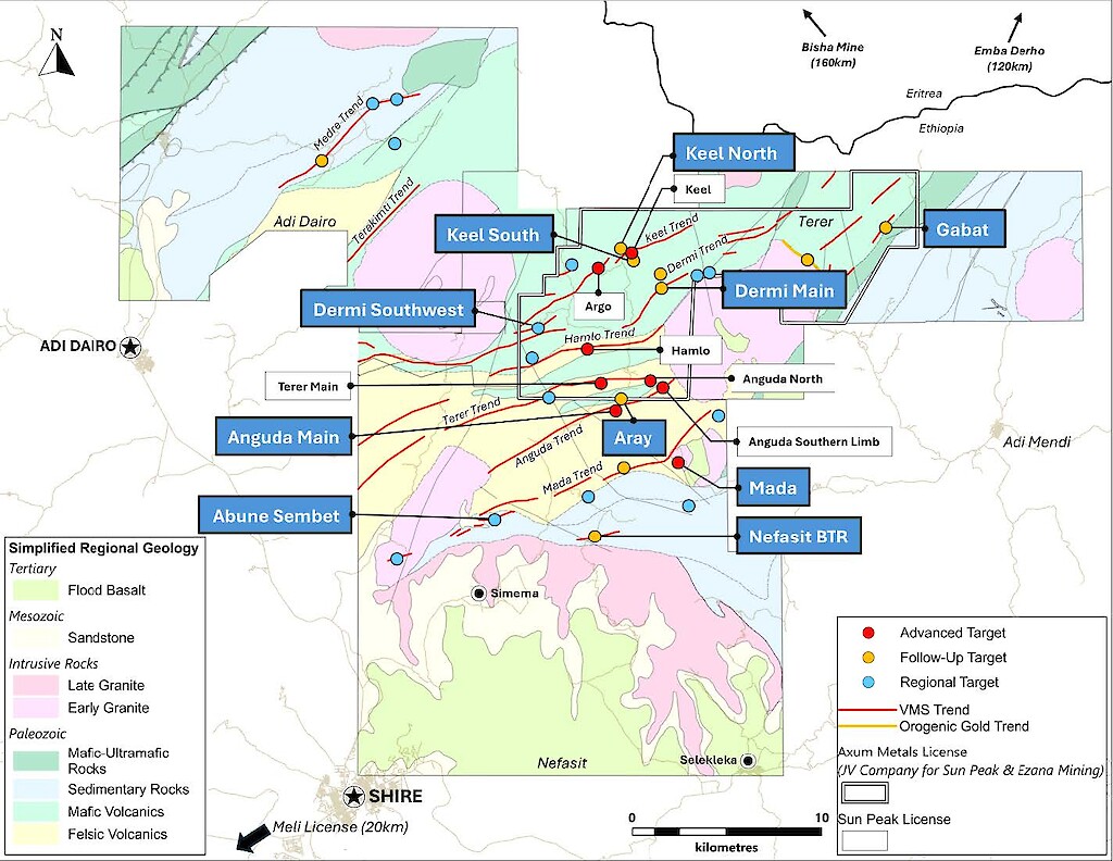
Terer License
Terer is a 180 km² exploration license under a joint venture with Ezana Mining. The area is comprised of 5 major VMS trends mineralized zones spanning totaling over 20 kilometers in length. Throughout these mineralized zones, numerous VMS gossans, with significant orogenic gold potential, remain untested along trends.
Previous drilling activities have been limited, particularly on the Argo and Keel VMS zone with approximately 60 holes drilled intercepting notable grades and widths of both gold and base metals.
Previous Exploration
- KL-006: 17.85 meters averaging 3.95 grams per ton of gold, 45.5 grams per ton of silver, 1.4% copper, and 1.6% zinc.
- AR-001: 6.57 meters averaging 1.34 grams per ton of gold, 54.3 grams per ton of silver, 6.3% copper, and 1.7% zinc.
- AR-005: 13.6 meters averaging 1.35 grams per ton of gold, 16.9 grams per ton of silver, 1.1% copper, and 1.7% zinc.
Terer Targets
Anguda VMS System/Trend
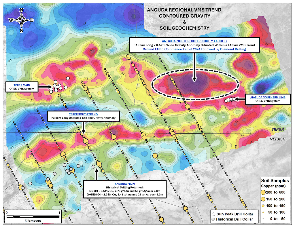
The Anguda VMS Trend, situated within the Terer exploration license, is a prominent VMS system extending for over 10 kilometers. Key targets along this trend include the Anguda North Target, Anguda Main Target, Anguda Main (N), Anguda Southern Limb Target, and the Terer VMS Target.
Recent drilling activities at the Hamlo and Terer VMS Targets, alongside limited drilling at the Anguda Southern Limb in 2020, have revealed typical VMS metal zoning patterns. The data suggests a potential increase in precious and base metal concentrations in other VMS zones within the Anguda trend.
The drill results at the Terer Target, outlined a VMS system along the trend of the Anguda North gravity high anomaly located approximately 2 kilometers east.
Anguda North VMS Target
Defined by a strong soil geochemistry anomaly, detailed ground gravity high anomalies, airborne VTEM conductor, and 800 meters long gossan outcrops. The gossan outcrops were defined in recent geological mapping work which was following up on the anomalies identified by the geophysical and geochemistry surveys.
Anguda Main (N) VMS Target
Defined by a greater than 1.5-kilometer-long mineralized zone of gossans and hydrothermal alteration horizons, plunging and increasing in size to the east. The target is identified by a copper and zinc soil geochemistry anomaly and a gravity high coincident with VTEM conductors.
Keel and Argo VMS Trend
The Keel and Argo Targets are part of a significant VMS system that extends over 6 kilometers and includes several other highly prospective targets such as the Northwest Zone (Figure 4). During the Company’s initial drill program in 2020, Sun Peak drilled 12 holes and intercepted high-grade copper-gold VMS mineralization at both Keel and Argo targets. The VMS zones remain open in all directions with untested gossans and gravity anomalies directly on strike from Keel and Argo. Future work will focus on extending these zones laterally and testing new zones along the trend.
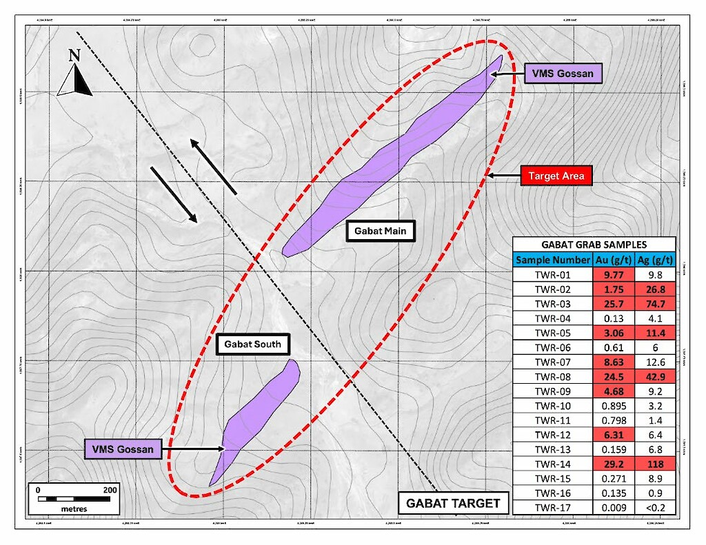
Gabat VMS Target
The Gabat VMS target consists of a 1.5-kilometre-long, northeast-southwest trending zone characterized by gold- and barite-rich VMS gossans. A total of 15 rock samples have been collected from the area. Of these, six samples returned gold values greater than 5 grams per tonne, with three exceeding 20 grams per tonne and a maximum recorded value of 29.2 grams per tonne. Additionally, six samples returned silver values above 10 grams per tonne, with the highest value reaching 118.0 grams per tonne. Detailed geological mapping and systematic rock channel sampling are scheduled for 2025.
Meda VMS Target
Defined by a 1.2 kilometers long gold, silver, copper, and zinc soil geochemistry anomaly, several gossan outcrops, and a gravity high anomaly. A single historic vertical RC hole was drilled in 2004 into the gossan which assayed 18 meters of 2.77 g/t gold from surface (Figure 5). Future drilling will attempt to define the VMS Zone laterally along strike and to depth.
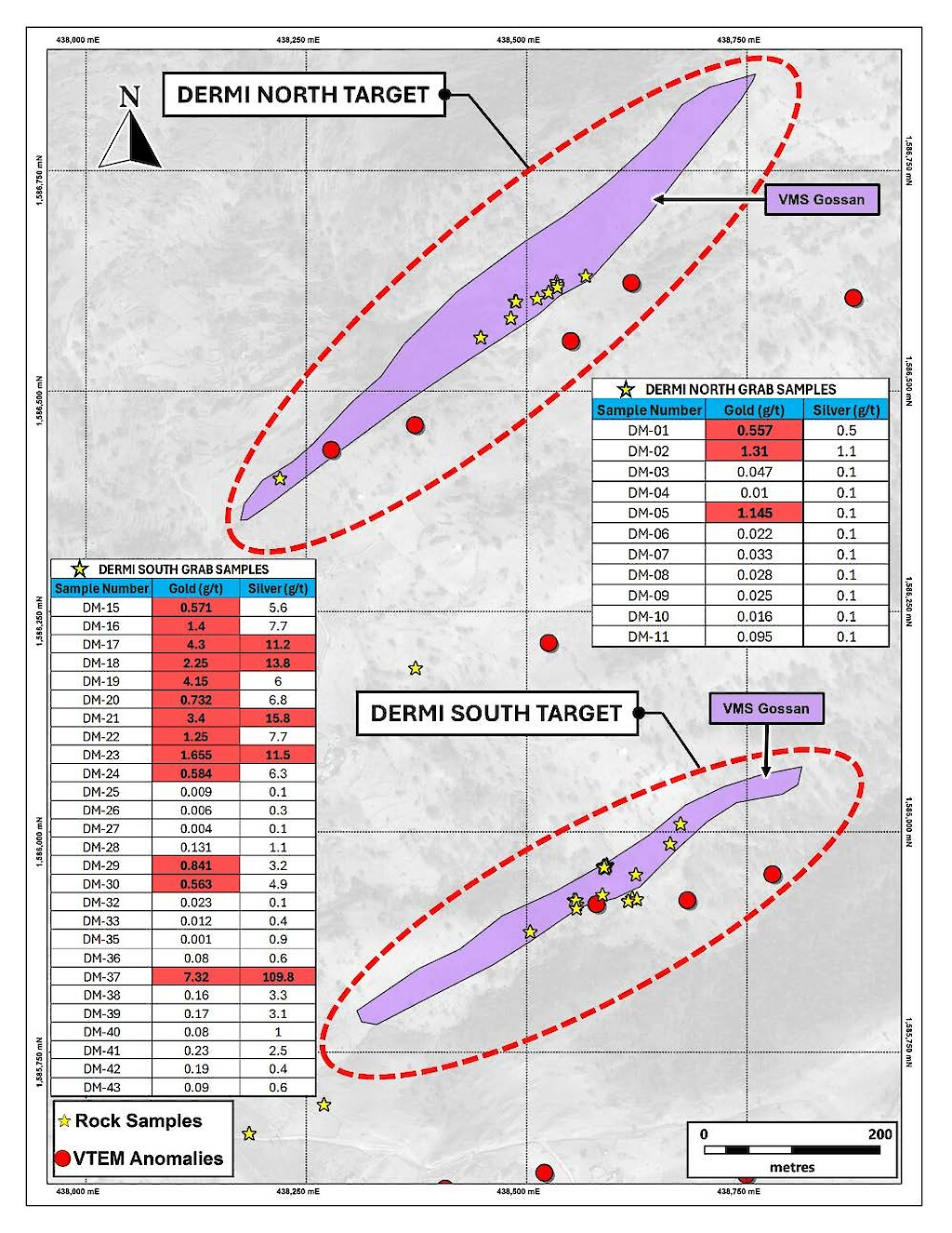
Dermi Main
Sub-regional geological mapping at Dermi Main has identified two sub-parallel VMS trends oriented in a northeast-southwest direction. At the Dermi South Target, detailed mapping and rock sampling have outlined a VMS gossan and stringer zone extending over 300 metres, coinciding with VTEM conductors. Rock samples collected from the Dermi Main VMS zones have returned values up to 7.32 grams per tonne gold and 109.8 grams per tonne silver. Planned future work includes additional geological mapping and rock sampling to the east, along with ground gravity and TDEM geophysical surveys.
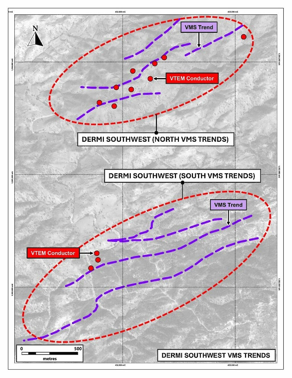
Dermi Southwest
At Dermi Southwest, sub-regional geological mapping has outlined distinct northern and southern VMS zones. In the northern area, three sub-parallel VMS zones have been identified, trending northeast-southwest over a distance of 1.7 kilometres and associated with VTEM conductor anomalies. In the southern area, four parallel VMS zones have been mapped, extending over 3 kilometres along a similar trend and also coinciding with VTEM conductors. Planned exploration across both zones includes detailed grid soil sampling, followed by geological mapping. Ground-based geophysical surveys, including gravity and TDEM, are also scheduled for both target areas.